


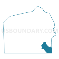
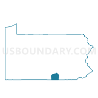
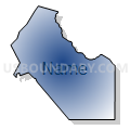
UNION TWP Voting District, Adams County, Pennsylvania
About
Outline

Summary
| Unique Area Identifier | 655613 |
| Name | UNION TWP Voting District |
| County | Adams County |
| State | Pennsylvania |
| Area (square miles) | 17.58 |
| Land Area (square miles) | 17.54 |
| Water Area (square miles) | 0.03 |
| % of Land Area | 99.82 |
| % of Water Area | 0.18 |
| Latitude of the Internal Point | 39.75587980 |
| Longtitude of the Internal Point | -77.04984770 |
Maps

Graphs
Select a template below for downloading or customizing gragh for UNION TWP Voting District, Adams County, Pennsylvania


Neighbors
Neighoring Voting District (by Name) Neighboring Voting District on the Map
- Carroll Precinct 03-001, Carroll County, MD
- CONEWAGO TWP VTD 02, Adams County, PA
- GERMANY TWP Voting District, Adams County, PA
- LITTLESTOWN WD 01, Adams County, PA
- LITTLESTOWN WD 02, Adams County, PA
- MT. PLEASANT TWP VTD 01, Adams County, PA
- MT. PLEASANT TWP VTD 02, Adams County, PA
- PENN TWP DIST 01, York County, PA
- WEST MANHEIM TWP Voting District, York County, PA
Top 10 Neighboring County Subdivision (by Population) Neighboring County Subdivision on the Map
- Penn township, York County, PA (15,612)
- West Manheim township, York County, PA (7,744)
- Conewago township, Adams County, PA (7,085)
- District 3, Myers, Carroll County, MD (5,516)
- Mount Pleasant township, Adams County, PA (4,693)
- Littlestown borough, Adams County, PA (4,434)
- Union township, Adams County, PA (3,148)
- Germany township, Adams County, PA (2,700)
Top 10 Neighboring Place (by Population) Neighboring Place on the Map
Top 10 Neighboring Unified School District (by Population) Neighboring Unified School District on the Map
- Carroll County Public Schools, MD (167,134)
- Conewago Valley School District, PA (27,315)
- South Western School District, PA (26,736)
- Littlestown Area School District, PA (14,575)
Top 10 Neighboring State Legislative District Lower Chamber (by Population) Neighboring State Legislative District Lower Chamber on the Map
- State Legislative Subdistrict 5A, MD (86,686)
- State House District 93, PA (71,712)
- State House District 193, PA (67,435)
- State House District 91, PA (66,509)
Top 10 Neighboring State Legislative District Upper Chamber (by Population) Neighboring State Legislative District Upper Chamber on the Map
- State Senate District 28, PA (284,462)
- State Senate District 33, PA (280,954)
- State Senate District 5, MD (129,604)
Top 10 Neighboring 111th Congressional District (by Population) Neighboring 111th Congressional District on the Map
Top 10 Neighboring Census Tract (by Population) Neighboring Census Tract on the Map
- Census Tract 224.02, York County, PA (7,744)
- Census Tract 307, Adams County, PA (6,493)
- Census Tract 5030, Carroll County, MD (5,505)
- Census Tract 218.01, York County, PA (4,527)
- Census Tract 313, Adams County, PA (4,434)
- Census Tract 311.02, Adams County, PA (3,179)
- Census Tract 312.03, Adams County, PA (3,148)
- Census Tract 312.02, Adams County, PA (2,700)